Notes and Links on Mari
Aug 3, 2016 7:55:53 GMT -5
Post by sheshki on Aug 3, 2016 7:55:53 GMT -5
From: Mari: Capital of northern Mesopotamia in the third millenium BC
by Jean-Claude Margueron

I: Presentation of the site
Conclusion: the history of Mari provided by archaeology
...
City I, founded around 2900 on a site with no previous human settlement,
was accompanied by a regional infrastructure consisting of an irrigational
network, a navigable canal and a derivative canal linking the city to the river.
The last preserved appears to belong to the beginning of the twenty-eighth century BC,
but as the tell was levelled during the re-founding, the exact date and the
conditions of its disappearance are not known. It is not even known whether
City I no longer existed when the levelling work for the foundation
of City II was undertaken.
City II was the product of a complete reconstrution, probably carried out
during the twenty-sixth century BC, and of a reactivation of the entire
hydraulic and urban structure. After a relatively short period of existence,
a century and a half or two centuries, it was completly destroyed,
probably by Naram-Sin, king of Akkad.
City III, built on the levelled ruins of this destruction, existed from
twenty-third century to 1760, first under the dynasty of the Shakkanakku
who reconstructed the city and then under the domination of Amorite kings,
whose last representative, Zimri-Lim, was defeated by Hammurabi of Babylon.
The city never recovered from this destruction, although remains of the
Middle Assyrian and Seleuco-Parthian periods indicate a sporadic occupation of the tell.

II. The foundation of Mari and regional development
The foundation of Mari on the Holocene terrace
...
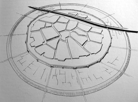
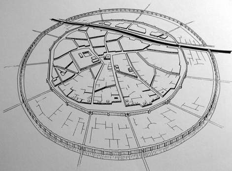
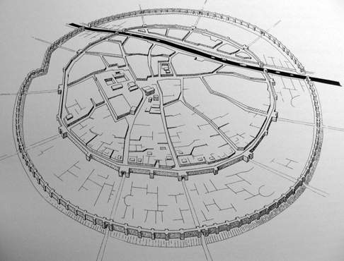
The topographical organisation of the architectural remains and their
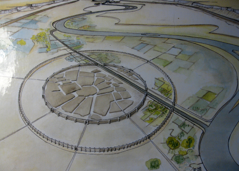
position in the valley show that Mari was established as a new city, created ex nihilo,
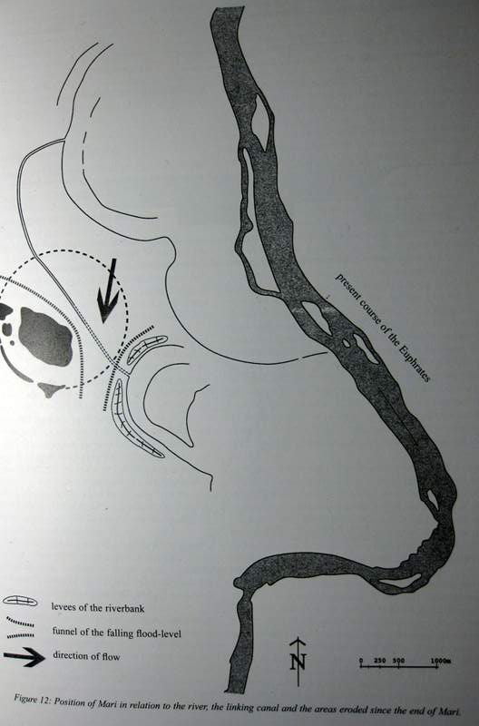
according to a circular plan 1.9km in diameter, on virgin land of the Holocene terrace more than 2km
from the Euphates, linked to the river by a canal. Its present-day morphology is the result
of erosion that has occured since the destruction of the city.
...
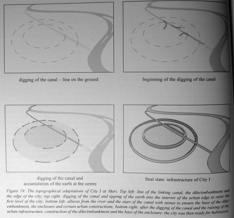
It is thus certain that the circular form of the city is that of its foundation.
Could this morphology be symbolic or religious? There is another reason to explain this shape.
The Euphrates is characterized by spring floods caused by snow melt from the mountains of eastern Anatolia.
Before the recnet large constructions were built to control the waters, on average flooding was
contained in the main bed of the river. But if the snows are exceptionally abundant and rain adds
to the process, then the river swells, breaks out of the main bed and invades the Holocene terrace.
The effects of flooding are terrible, not only for the crops destroyed but for all earth-built human
constructions, including houses and canals; if a volume of moving water invades an area of land,
it easily attacks all constructed angles, ...
But a curved shape causes water to flow past rather than attack.
...
But probably the most important reason for the choice of a circular shape was to facilitate
the elimination of rainwater towards the periphery. A street network radiating
from the centre of the city was the solution for this function of evacuation.
It appears that the circular plan, the distance from the river and the linking of the site
to the river by a canal are the features that are closely related. They are aspects of a
preconceived plan that implies a good understaning of the phenomena that it was necessary to dominate.
by Jean-Claude Margueron
I: Presentation of the site
Conclusion: the history of Mari provided by archaeology
...
City I, founded around 2900 on a site with no previous human settlement,
was accompanied by a regional infrastructure consisting of an irrigational
network, a navigable canal and a derivative canal linking the city to the river.
The last preserved appears to belong to the beginning of the twenty-eighth century BC,
but as the tell was levelled during the re-founding, the exact date and the
conditions of its disappearance are not known. It is not even known whether
City I no longer existed when the levelling work for the foundation
of City II was undertaken.
City II was the product of a complete reconstrution, probably carried out
during the twenty-sixth century BC, and of a reactivation of the entire
hydraulic and urban structure. After a relatively short period of existence,
a century and a half or two centuries, it was completly destroyed,
probably by Naram-Sin, king of Akkad.
City III, built on the levelled ruins of this destruction, existed from
twenty-third century to 1760, first under the dynasty of the Shakkanakku
who reconstructed the city and then under the domination of Amorite kings,
whose last representative, Zimri-Lim, was defeated by Hammurabi of Babylon.
The city never recovered from this destruction, although remains of the
Middle Assyrian and Seleuco-Parthian periods indicate a sporadic occupation of the tell.
II. The foundation of Mari and regional development
The foundation of Mari on the Holocene terrace
...
The topographical organisation of the architectural remains and their
position in the valley show that Mari was established as a new city, created ex nihilo,
according to a circular plan 1.9km in diameter, on virgin land of the Holocene terrace more than 2km
from the Euphates, linked to the river by a canal. Its present-day morphology is the result
of erosion that has occured since the destruction of the city.
...
It is thus certain that the circular form of the city is that of its foundation.
Could this morphology be symbolic or religious? There is another reason to explain this shape.
The Euphrates is characterized by spring floods caused by snow melt from the mountains of eastern Anatolia.
Before the recnet large constructions were built to control the waters, on average flooding was
contained in the main bed of the river. But if the snows are exceptionally abundant and rain adds
to the process, then the river swells, breaks out of the main bed and invades the Holocene terrace.
The effects of flooding are terrible, not only for the crops destroyed but for all earth-built human
constructions, including houses and canals; if a volume of moving water invades an area of land,
it easily attacks all constructed angles, ...
But a curved shape causes water to flow past rather than attack.
...
But probably the most important reason for the choice of a circular shape was to facilitate
the elimination of rainwater towards the periphery. A street network radiating
from the centre of the city was the solution for this function of evacuation.
It appears that the circular plan, the distance from the river and the linking of the site
to the river by a canal are the features that are closely related. They are aspects of a
preconceived plan that implies a good understaning of the phenomena that it was necessary to dominate.